 .........................

| ..........
.............................................................................. .................................................................................................................................... .............................  ....................................................................................................
 ..................................................................................................................
Nothing
presently exists of the original Friendship
Airport building , currently known as BWI ,
Thurgood Marshall Airport. The airport, just
south of Baltimore City, is on 3,300 acres of Anne Arundel County Maryland
land. When the airport opened in 1950, it was
said to cost $15,000,000, and was said at
the time, to be four times larger than New
York's La Guardia Airport and five times larger
than Washington D.C.'s National Airport.
Friendship Airport got it's name from the old
Friendship Methodist Church that once occupied
the site. When the airport was being planned in
1948, it was the second regional airport in the
Baltimore Washington area, the first being
Washington National Airport . The main
runway, when Friendship first opened, was
reported to be 2 miles long. The newer - BWI -
Thurgood Airport has been built over the same
site. When the airport first opened and
throughout the 1950's, maps would often listed
the address as " along the Baltimore Expressway
", an early name I guess for the Baltimore
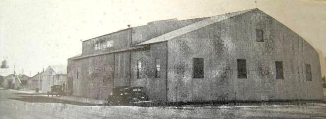
Washington Parkway. ......................................................................................................  .................................  .............................Just before opening, the new Friendship airport awaits the big day in June of 1950. ..................................  ....................
... .   .............  |
...................................... .................The good old days....... Pulling up in front of the Airport and "waiting for a while". |
...  |
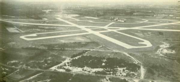
.........................................................//........... .........////////////////////////////////////////////////////////////////////////////.....................................................Aerial photo of Friendship soon after it opened. ....................................................  .............. .............. |
........../////////.......................................................................... ..........  ..........................................................................................................  |
|
Above, several
opening day promotional shots of Friendship
airport in Anne Arundel County Maryland. Below
left , an early postcard of the airport, and
below right, a view from the runway and the
observation deck. . .........../////////////////////////////////////////////////////////........................................... ...Lobby of Friendship Airport back in the 1950's.. .Postcard view of the Lobby of Friendship Airport when it opened ( above 3 right ). Friendship Airport might have been where the first branch for a bank in a airport was located, with the opening of the Fidelity Trust Office, which was a bank branch enclosed in glass walls. ( Information thanks to Ed ) //////////////////////////////////////////////////////......................................... 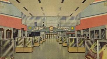 ....... Early aerial view of Friendship Airport ( above four ) , shows only a few planes on the ground and one large hangar. The early days were not good for the airport as traffic was not quite what officials had expected, but with the advent of jet planes, such as DC8s. 707s and 727s, the airport became very successful. This entire building , which contained three piers and three levels, has since been torn down and replaced with Baltimore Washington International Airport. The airport was named after the area, known as Friendship, in Anne Arundel County, just south of Baltimore City. ..............................................//.........  Lost are the days when you were allowed to go right out on the roof of the airport and view the activity from the Observation Deck. I never made it to the old observation deck at Friendship, but today's BWI observation area is enclosed, which is ok, but not quite as exciting. |
..../////////.............................................................. ............ ............ |
//////////////////////////////................   |
.......................... |
................. |
...........//////////////////////////////................................................................. .............. .............. |
...........//////////.................
 |
.//////////////////////////////////........  |
............. |
////////////////////////////////////...... |
...........................  |
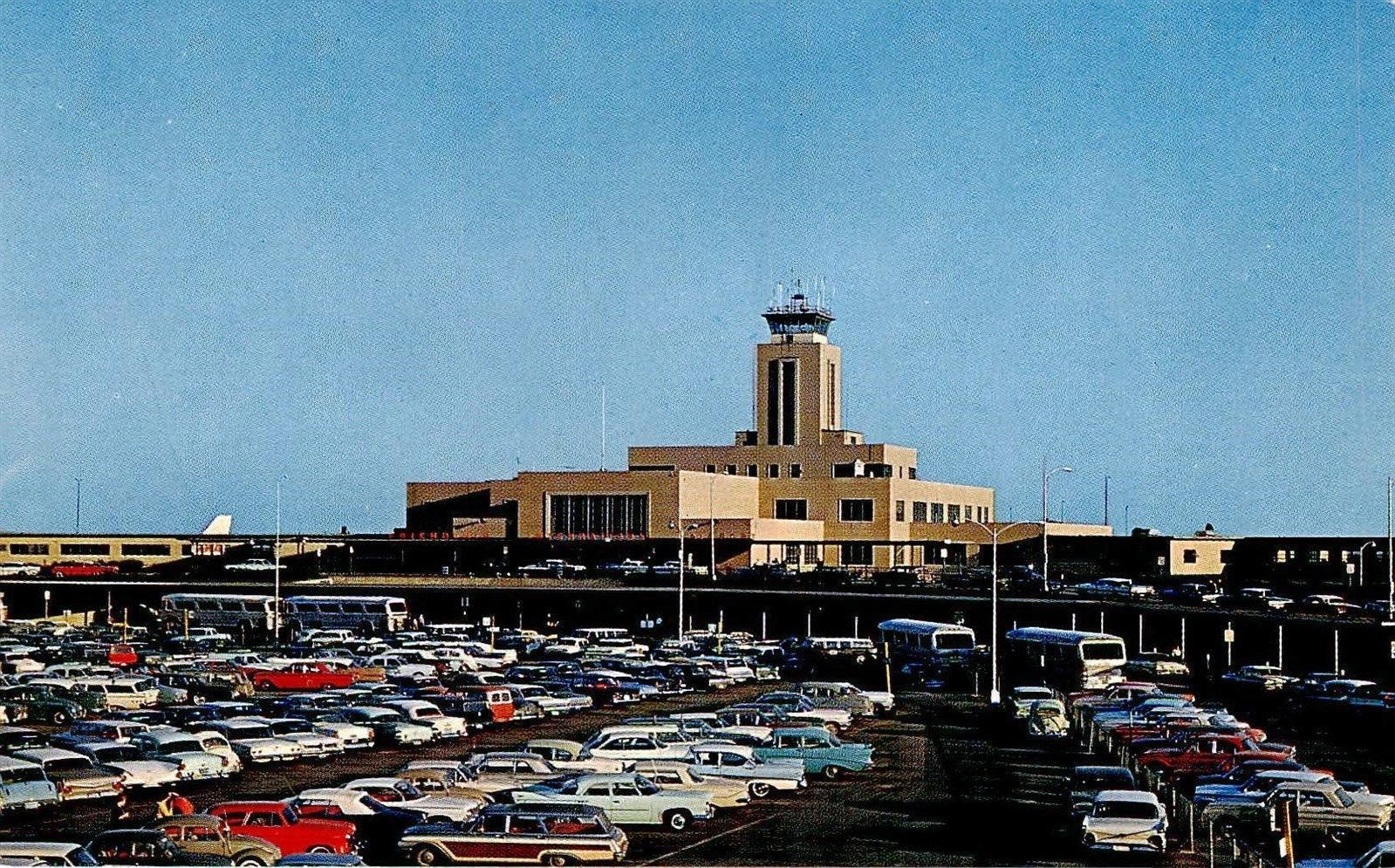
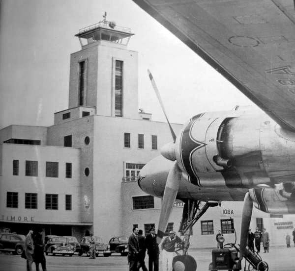
................................................................... Replacing the Dundalk Airport in Eastern Baltimore City and County ( listed below ) , Friendship Airport was quite an exciting opening day for folks all around Maryland. Below, Friendship's parking lot with a few spots visible, and well within walking distance of the airport. Times have changed as the parking lots are now multi- storied garages and the airport has satellite lots for long term parking as well. Below right, a look at the runways when the airport first opened, and far below left, the airport with two planes awaiting passengers. ........///////////////////////////////////////........................  .... ...................//////////////////////////////////////////////////////............................................. ...................................................TWA ticket counter, Friendship Airport - Baltimore Maryland circa 1950's .......................................  .......................................................................................  |
..//////////////////////////////////////////////.... |
............  |
.//////////////////////////////////////////////////...  |
.......  |
| A few new
entries for the Friendship Airport page that I
obtained a opening day booklet for the Baltimore
Civic Center , now known as First Mariner Arena.
The booklet had all sorts of material on early
1960's Baltimore, which included these three
pictures of a typical day at Friendship Airport.
By 1963, Friendship airport boasted of a 9,450
foot runway, which could handle any jet at that
time. For years the airport was owned and operated
by the City of Baltimore, with 145 Municipal
employees and 1,400 employees working there in
1963. At that time, there were 150 daily flights,
11 airlines and 19 gates available.
Ownership later went over to the State of
Maryland. .................................................................................  ............................................................  |
......... |
....  |
.......................................................... . .........................................................................  ..................................................................................................................  |
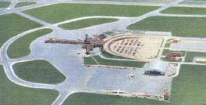
.................................................... ............ Baltimore Sun Photo Tribune Publishing - Lloyd Pearson 1977 ........................... Out with the old - in with the new, the replacement of Friendship Airport and the building of BWI right next to it. ...................................................  BWI in the 1980's, prior to the building of a massive parking garage, which went up in the late 1990's to 2000. The early airport of the 1960's had a parking lot which would only hold 1,900 cars. .........................................................................................................  ......................................... .....................................................  |
| ..........................................Harbor
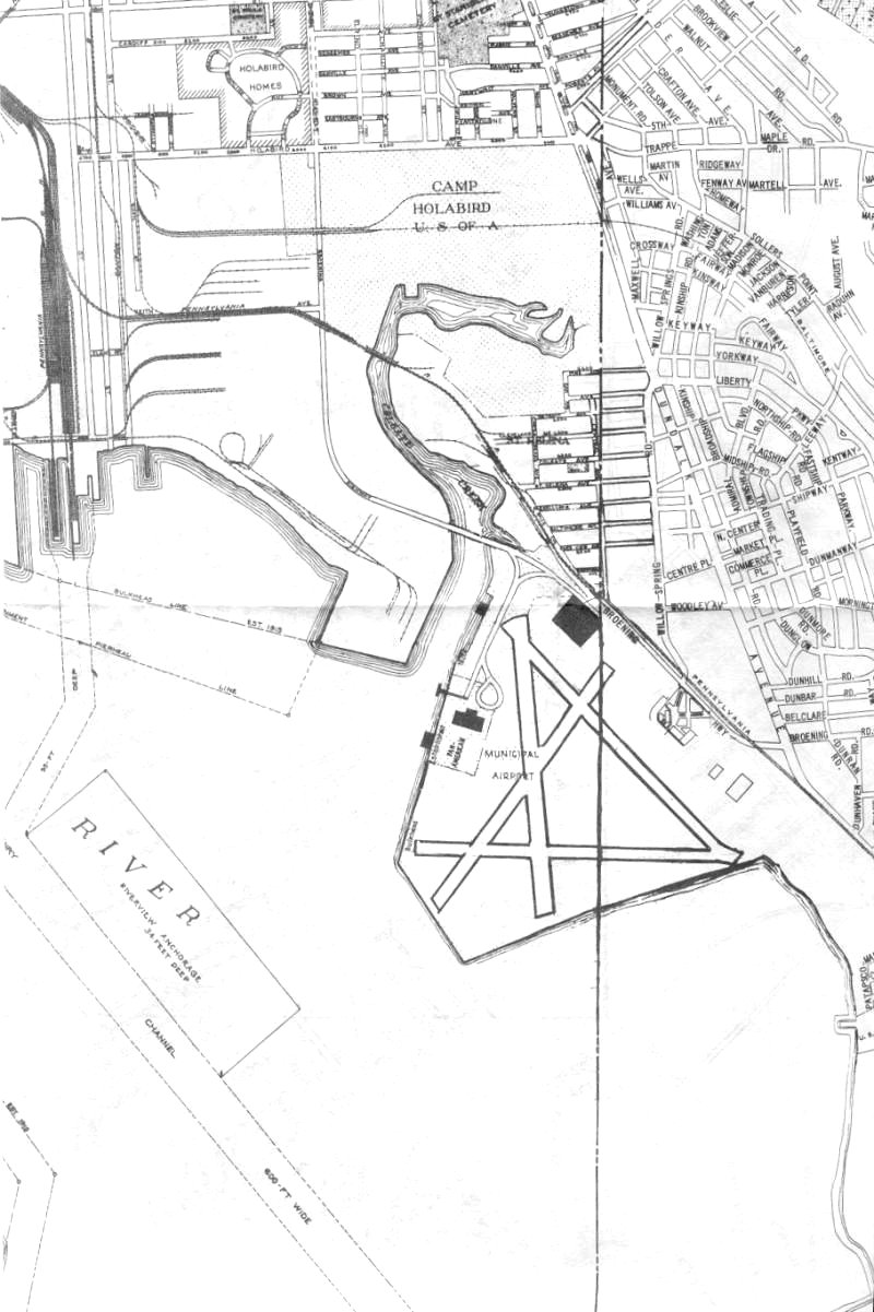
Field - Municipal Airport Before Friendship Airport, ( later known as B.W.I. / Thurgood Marshall Airport ) opened up in 1950 , Baltimore had several smaller airports around town. The largest and most used was Harbor Field in Dundalk Maryland, located just Southeast of the City, in Baltimore County. The airport, also known as Baltimore Municipal Airport and even Baltimore Airport, was located on the Patapsco River at Colgate Creek. The site is now a part of the Dundalk Marine Terminal. The airport opened for seaplanes in the early 1930's, as City Officials hoped that the airport would be one of the Country's largest airports as water landing were thought at the time to be the wave of the future in air flight. Baltimore offered better weather than NYC, and on occasion Harbor Field was used by planes to land when NYC had bad weather. .....................................  |
............................................. Above and above right - Two photos from " The Maryland Scene " , circa 1945 |
.......
|
.................................................  |
................  |
.................................................................... ............................................................... .............. ..........Baltimore Sun Photo Tribune Publishing - Much of the airport was made by dredging and for over 13 years, the attempt at making the world's greatest airport was hampered by runways that would not settle in and would sink. Later, land operations started at the airport in the early 1940's. The airport simply went by the name of Harbor Field by 1950 and closed for good by 1960, as jets and landing runways took over at Friendship Airport in Anne Arundel County , with the old field being used by the Federal government for several years, until it was torn down and later made into the Dundalk Marine Terminal. Below right, you can see a map of the old airport, located at the intersection of Broening Highway and Dundalk Avenue. ......../...................................................  ........///////////////////////////................ ....................  |
///////////....  |
....... |
| .....////////////////..... ........  |
...........  |
....///////////......... ..  |
...  |
......  |
.............. |
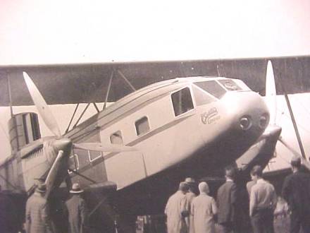
| By 1939, the Yankee Clipper
planes began to fly into the airport. The first
three pictures are off those planes, while the
fourth ( below right ) is of a smaller seaplane
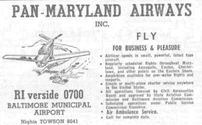
landing at the airport, circa 1939. Below, several ads for the Municipal
Airport from an old phone book from 1949. A few
years later, the airport would be closed down, with
the opening of Friendship Airport. ..........................................................................................................  ....................................................................  ..........................................................................
 .......................................................  ................................ ................................ |
.............................................. |
..........
|
........................................................................................................................... 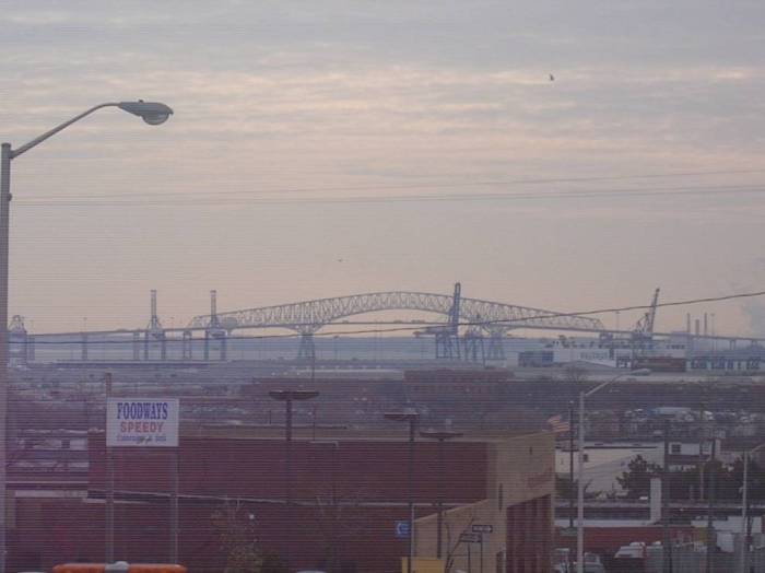 ........../////////////////////////////.......... .........Looking south from Broening Highway , this view ( right ) today shows the Dundalk Marine Terminal ( Best view I could find ) , where if the plans had continued as were hoped, you would see in this view planes taking off and landing. A major port facility occupies the site today..........................................................  |
| ..........///////////////////.................... ............  ................................................ .............  ................................................................................................................................................Above 2 pics - Maryland Air National Guard ...........................  .......................................................................
 ..A few old advertisements for Harbor Field circa 1945. Years later, Friendship Airport would open and the " jet age " would begin. |
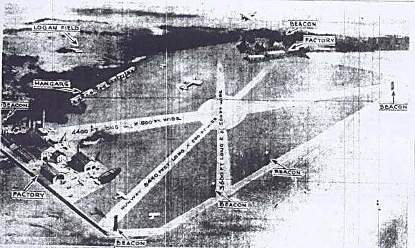
| Logan
Field In the 1920's, Baltimore realized it needed an airport, and Baltimore's first airport, Logan Airport, located in the Dundalk area around Dundalk Avenue and Belclare Road was built. The airport first opened as the Dundalk Flying Field, but the name was changed in honor of pilot Lt. Patrick Logan, who died when his biplane crashed near the location in the 1920's. In 1930, Eastern Air Transport Inc. began passenger service from Logan Field to New York City, and South to Richmond Va. Planes were also available direct to Miami Fl. Ludington Air Lines also had flights to New York and Washington DC.................................................. .................................................. .....................................................................  .............................................................................. ......From the Collection of the Maryland Air National Guard The field went by the name of Baltimore Municipal Airport for a while, but by the mid 1940's, closed down to be replaced by nearby Harbor Field. The below right shot shows what I believe is a pilot of a Baltimore Airways plane at Logan Field, back in the 1920's |
.....  |
..... |
..........  |
 |
| ...By the late 1920's, commercial
flights ( above ) began at the airport,
and by the mid 1930's, even American Airlines
flew out of the airport. ........................................ ..........................  .........................................................................................................From the Maryland Air National Guard Collection .....................................................................................Logan Field, 1930's, and behind it, the soon to be Harbor Field. ....................................................................................................................  ........By the late 1940's, housing replaced the airport. The photo of the house, left below is of the intersection of Dundalk Avenue and Belclare Avenue, circa 2008, showing no trace at all of the old Logan Field. |
| ............... ...............  |
..........  ......A early 1920's road map showing the location of Logan Field, indicated by the # 2 in blue gray. This older map has no mention of Municipal ( Harbor Field ) Airport, to be built later just North of "Balnew". To the left, a late 1920's aerial shot of Logan Field. |
.................................................  .....................................................................So much for radar ! A local business shows pilots where the airport is. |
| ................................................ |
//////////////////// |
| .......Also helpful for pilots coming into
Logan Field were these very powerful lights,
perched on top of the Standard Oil Building and
Lord Baltimore Hotel, in downtown Baltimore,
circa 1929. ........................................................  A 1927 tribute to the crossing of the Atlantic by Charles Lindbergh, six small aircraft fly out of Logan field and across Baltimore to mark the occasion. Below, several old ads from a Baltimore Directory dated back to 1940, as air traffic became to move from Logan to the larger Municipal Airport nearby. ....................................................................................  .................................................... .................................................... |
| Curtiss Wright Airfield I'm still gathering the details on this small airfield located in Northwest Baltimore, but I have located a map, which clearly shows the airport, and a picture of a shopping center, that is now located on part of the old airport. The rest of the airport was developed into housing. One emailer wrote Kilduff's to tell of playing in the abandoned hangars of this airport many years ago. The airport appears to have been constructed around 1930 ,and vistors back then included : Col. Charles A. Lindbergh and Wife, Miss Amelia Earhart, Mr. Clarence Chamberlain , among others. |
.......... 
|
...................... |
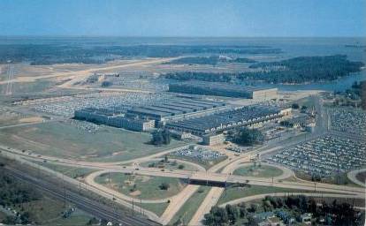
| Glenn L Martin Airport ....................................................  ...................................................................................... Glenn L. Martin State Airport .............................................  .................................................................................Glenn L. Martin Airport is still open to this day. .........................................................  |
....  |
... |
...............  |
...  |
.............................................................  |
.......................................  ...............................................  .......................................  |
................ No, you're not going to grab a flight out of Patuxent, but it's still in Maryland and it's a neat postcard, sooooo....... .....................................................  |
............................................................. Anybody from Baltimore knows, when you do book a flight out of Town, it's the three airport option. While BWI is usually the best, it's not unlikely to fly back into or out of Washington D.C. ..................  .................  ...............  ..........................................................  .............  .........................  ..............................  |
| A few mysteries were under
covered while investigating the history of
Airports in Baltimore. Above left ,
plans for a Lindbergh Field in Baltimore, likely
plans to update Logan Field or early plans for
Harbor Field. ( Several emailers have
confirmed this ) ...........................................................................  ......Below, a few old postcards found of the first flight over Baltimore. The first is of Herbert Latham's "Antionette", likely the first plane to fly over Baltimore. To the right, Aviator Radley flying his Monoplane in Halethorpe, which is southwest of Baltimore, getting ready for the historic 1910 flight. Apparently the event drew a lot of attention in Baltimore and Halethorpe. |
..............................  |
...... |
................................................................  |
................  |
............................................  |
.................................... ......................Please feel free to email us with the link above. |
| If you enjoyed this page, please
feel free to check out the entire Kilduffs web
site. Comments and suggestions are welcome , just
click the Kilduffs image above right. Still
looking into Rutherford Field on WIndsor Mill
Road, Hendlers Field in Reisterstown, Essex
Seaplane Base , and Glen Burnie Airport in Glen
Burnie, all found mentioned when researching the
City. ..................................................................  ........................................................................................................................Aberdeen Airpark, Harford County, circa 1953 Aberdeen Airpark was started in 1947, and built on the site of the old Bradford Estate. Back in the 1950's, it had two sod runways and parking for atleast 12 airplanes. ........  .............................................................................................................................................................................................................Ocean City, Maryland Airport, Circa 1960's ..................................  ...............................................................................................................................................................................................Rutherford Airport - Just Outside Baltimore City ........................  ...................................................................................................................................................On the Web since August 2002...................................................................................... |
